Wednesday, August 30, 2006

Trail Review: Chonburi, Banglamung -- Tam Pratoon

Challenging and fun, this course has the complete package ... thats why everyone is flocking to it.


Location:
Khao Mai Gaew Reservoir, Banglamung, Chonburi

Trail Length: 11km (long loop), 7km (short loop)


Jump-off Point:
Starting from the parking lot, you head into a small fireroad on the left side of the reservoir. A couple of hundred meters and you will see a singletrack heading away to the right. Get in, and you're on!


The Trail:
As this is a popular destination, direction arrows litter the trail. You will also observe that there are signs with orange and red triangles. These signs indicate that the trail is a mountain bike trail (orange triangle) or a motocross trail (red triangle)!? Or is it the other way around?

First up will be a curvy singletrack alternately ascending and descending. The track is sandy and loose on a sunny day, but hard and rut-lined if there had been recent rains. This section will get you nicely-warmed up. Watch out for loose sand on the curves.

Abruptly, you will come across a crudely constructed wooden gate. Keep it always closed, even if you find it wide-open when you get there. Reason is that there are domesticated cows in the area and the gate prevents them from wandering into the vegetable patches that litter the area. You dont want to meet an angry farmer on your next ride - keep the gate closed.

Again, curves and zigzags, but this time slightly ascending and full of tree roots. Yep, at this time you should have worked out quite a sweat and should be starting to get tired from lifting your handlebars over roots. Its wise to set the front suspension to a softer setting and the tire pressure on the soft side.
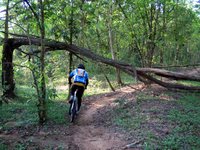

Take particular attention to tree roots on quick switchbacks, make sure that you have landed squarely on the other side of the root before you jerk the handles to change directions. Change directions too quickly and you might land awkwardly on your front tires.
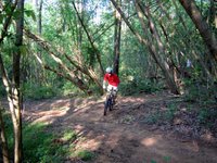

After this zigzag-gy section, you will then arrive at a narrow long, long and steep uphill. This is the first uphill section and easily separates who has been good during the week and who has been spending too much nights partying.
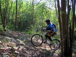


Dont worry, rest area up ahead. At the top of this long climb, the trail forks to the right and left. Trail to the right is hardly used and is very technical. At most times, its just too unkempt to ride in. At certain times of the year, somebody cleans up the trail, cuts the undergrowth and can be used.

The trail to the left is the more traveled one. Head to this one. Dont forget to change settings of front fork to downhill mode, as this is a long semi-steep descent. For most, this is the fun section .

At the bottom, watch out for rain ruts running parallel to the road, as your front tires could get caught in them. Cruise along until you reach a dark patch of forest.

Again, you will reach a fork up ahead. Fork to the right is a short cut, while the one on the left leads to a eucalyptus forest. Very nice and otherwordly. Just to see this section makes it worth the extra kilometers. Any forks on the trail that you see, just take right turns. Direction arrows will also guide you on this part. There will be an 'X' to tell you where not to go.


Next up, would be two succeeding uphill climbs with a short downhill between them. Curvy and steep, the uphill climbs are quite a mental challenge. Grit your teeth, give your quadriceps a huge pep talk and start working.

Most riders would go at it until the 3rd peak, and then take a short breather. There is a short clearing which is cool and shady. Find a good spot to rest and be familiar with the place. You will definitely come to stop here on future trips to tam pratoon.

From here, its all downhill -- Yay! Not quite. The downhill section is strewn with boulders and quite steep. Very scenic, but who can enjoy the view while watching out for rocks on the trail. Rain ruts also add to the difficulty. Keep to the left, if in doubt. The best lines are normally on the left side of the trail. Add a bit of caution when riding through this section.

At the foot of the hill, it is all easy-going from here on. Still twisting and turning, just follow the singletrack and then suddenly, you find yourself on the same parking lot that you left. Wow, at this time, that would seem ages ago. Go sit down and rest on the pavilion and think about the ride. Give it a few minutes, you might want to have another go.
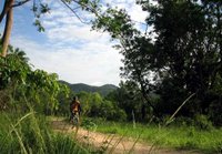

This time, look at the scenery. It is really beautiful.


Fitness Level:
You should be fit if you want to tackle this course in one go. The uphill climbs, there are 3 of them, would definitely humble you.


Technicality:
This course is a technical one. There are a lot of switchbacks - alternating both uphill and downhill. And there are a lot of tree roots across the trail. Can be slippery especially after a monsoon rain. The roots make it harder to climb, and make it tricky on the short descents.

Be careful on the quick turns, as the roots make your front wheel 'jumpy' and lose grip as you change directions. I know its basic stuff, but keep both your hands firmly on the handlebars and your concentration fixed. Add to that some loose sand and you will lose control of your ride rather quickly if you start daydreaming.
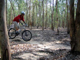
Tires should be a bit soft from what you are normally accustomed to lessen the jarring on the front tires.

On the descents, beginners would balk and think twice on these, especially on the third and last one. This is a long steep descent littered with big boulders. If its your first try, be conservative and learn the best lines to take, as picking a bad line could easily send you flying over the handlebars.


Trip value:
Being half an hour drive to Pattaya, need I say more? A day on the beach, beer on the evening till 2am -- you probably know more about it than i do.


How to Get There:
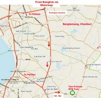
If you are coming from Bangkok, take the Motorway (Rd.7) and follow this until you reach Kratinglai Junction, which is the huge cloverleaf splitting the road heading to Pattaya and to Rayong. Take the left turn to Rayong (Rd.36) and begin to slow down. About 1.5km from the junction, turn left Rd.3240.

Travel about 6km into Rd.3240, and you will arrive at a small country road with a big colorful sign beside it (if you arrive at a 4-way intersection with traffic lights, you'd have missed it and need to backtrack now. Dont lose your cool now, just make a U-turn on the PTT gas station. Its 900 meters from the intersection, but now its on your right side).

Turn left into the country road and about 500 meters, you will arrive at a big garden and a parking lot beside a medium sized reservoir. Make a sigh of relief and get ready to have fun!

[end]
Tuesday, August 29, 2006

Trail Review: Chonburi, Sriracha PongDingDum TestTrack

Location: Sriracha, Chonburi
Trail Length: 10kms
The Trail: Double track with a short singletrack near the end of the loop. Lots of loose rocks on downhill sections, rain ruts on some corners.

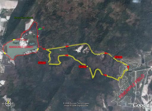
Jumpoff is at the parking lot of the abandoned sand quarry in the PongDingDum reservoir about 1km past the Golf Course. Vehicles can be parked here or in front of KhaoKeaw Zoo for a nice, refreshing 3km warmup.

The trail is mostly fireroad, jeep and motorbike trails used by pineapple farmers, with a very easy downhill singletrack from Apex2. CAUTION: the trail marked in yellow in the map above is also used by 4x4 truck drivers, there are no trail markers, and there will be the occasional mountain bikers going in the opposite direction so pay attention when approaching blind turns.


Easy grind uphill from the takeoff point is quickly rewarded by a fast, straight downhill A. Watch out for loose fist-sized rocks. Take a left at the fork at the base and follow the fireroad.

There is a 3m-wide, 1m-deep gap as you approach Apex1. The workaround is at the left side of the gap and you may have to dismount and carry your bike. If you think you can jump your way across, don't forget to take a pic or a vid and post it here because we'd like to see you nail this one.

Not far from Apex 1 is the Pineapple Field. Enjoy the sunlight and DO NOT mess with the crops.

As you exit the field, follow the track which goes downhill towards the hairpin to a moderate climb to Apex3. Not very steep so go ahead, flex your muscles and mash.


Easy flowing track follows with VERY tall and VERY sharp blades of grass on both sides esp. during the rainy months (July - October). TIP: Wear eye protection; insects will be literally on-your-face thanks to your buddies riding up front. Pictures here were taken last summer so the grass are mostly dead, burnt, and dry.

There is a VERY steep, 50m climb before Apex2. Lots of loose rocks on the center and towards the left of the track so keep right. Ground is a bit loose even during the wet season so pay attention decide to get off the saddle and hammer.


At the top of Apex2, turn right to the wide grassy field to a short downhill singletrack. At the end of this trail is a T-section - right leads you back to the loop, left leads you out around the reservoir and back to the parking lot.

Fitness level: Beginners. You can pretty much zoom through this in no time following the clockwise route or you can challenge yourself and go the opposite.

Trip value: Near one of the better places to find great tasting charcoal-broiled chicken with matching sweet spicy sauce that can only be found in this area.

How to get there: The trail is about 130kms from Bangkok. Follow the Motorway (route 7) going to Pattaya. Once you reach Chonburi, pay attention to signs leading to Khao Keow Open Zoo. They will lead you to a left turn from the motorway towards the zoo.

Monday, August 28, 2006

Trail Review: Chonburi, Pattaya -- Phra Tamnak Hill

Short downhill and Cross Country XC trail right in the heart of Pattaya

Make it a weekend with your family and friends in Pattaya. This mountain bike course is right smack in the middle of the Phra Tamnak Hill, jutting at the foot of South Pattaya.


Scenery
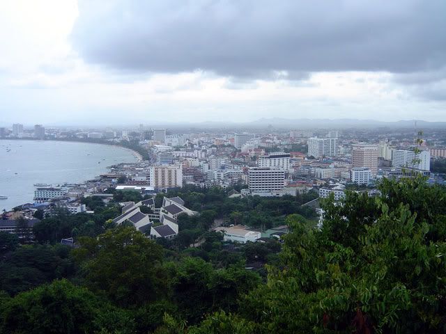
Postcard-perfect! Perfect view of whole city of Pattaya and the bay area.


Trip Value
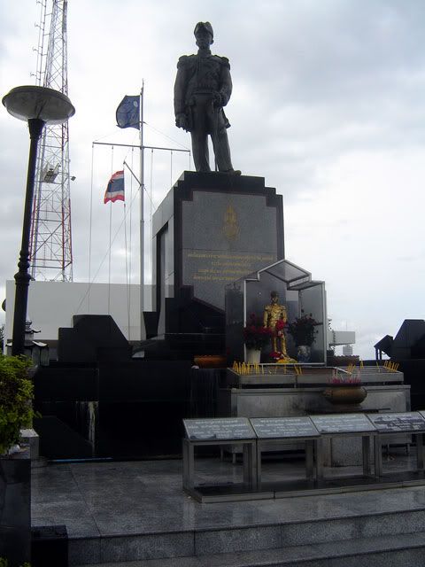
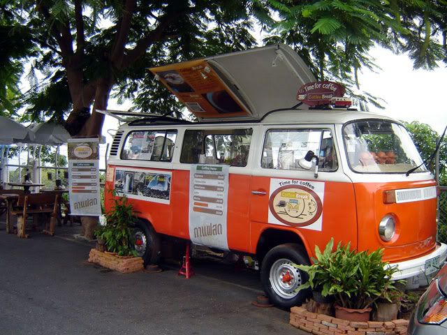
Coffee served from a converted Kombi at the hilltop, a Wat, and a monument to a great Thai Admiral can be found at the top of the hill. This is one of the rare instances where you could bring your beloved half, make a quick offering at the Temple and let her sip coffee and enjoy the view. Just dont let her look at the downhill course or you may get grounded for weeks.


The Trails
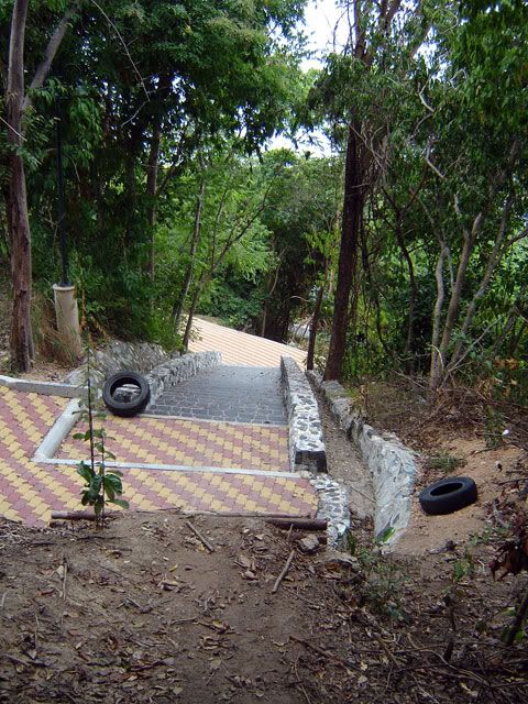
There are 2 courses in the hill, and i tell you there is a Dr Jekyll-Mr Hyde aspect to these course. One is a winding XC on well-paved footpaths. Very gentle and civilized. You could bring the family along on this course. Cruise along, take pictures ... sit on the benches, even have a picnic.


The other course is a short downhill, but very mean and nasty. This is the Mr Hyde part. I will not recommend this trail for beginners or the occassional weekend warrior. Highly technical and competition level -- only for advanced riders please. The jump-off is a small platform right behind the coffee shop. For this downhill course, that is all you need to know as everything will go rushing past anyway. Anything I describe will be just a blur to you after the jump-off. Seriously though, I suggest you scout the course first on foot and go through the lines to get past the various obstacles. There will be lots of air and jumps on this course.

Firstly, before attempting to take the downhill course, bring protective gear and bring ALL of it. Full-face helmet, body armor, arm and shin guards, heck, if you can find your grandpappy's old flak jacket from WWII, then bring it as well. The mountain bike gurus always say, "dress for the crash and not the ride", then on this course, dress for a HUGE crash.

The downhill course cuts into public pathways at two points. Always keep this in mind especially on crowded weekends. You will find yourself landing right in smack of the public pathway before continuing onto the other side. Best that you dont get surprised by this, or worse, surprise a wobbling retiree out on his daily stroll.


Mind the picture on the left -- this was taken on a ledge about a meter high from the pathway and straight into a long stair. As you approach the ledge, prepare to get some air beneath you. You will land on the footpath and straight onto a flight of stairs.

Very short and very fast. You are at the bottom before you know it.

The only way up is via the front road uphill. It is a long grind. To keep you motivated, think of the hot steaming coffee with the spectacular view at the top. Or, another round of high-adrenalin professional level downhill run.


Fitness Level / Technical Skills
Minimal. The XC on the paved footpaths are easy and quite flat. Not much work there. Anyone can ride this course, as everywhere its smooth and cultured.

On the downhill trail, gravity does the work anyway. No requirement to be fit. The course could be fitness 'optional' but technical skill - mandatory. No place for beginners, only advanced riders please.


How to Get There
Go straight to Pattaya. Cruise past Pattaya South road until you reach Tepprasit Rd. This is the one leading to Jomtien Beach. Head into Tepprasit and turn right at the end of the road -- left goes to Jomtien, while the right goes to Phra Tamnak Hill. Watch out Phra Tamnak Rd on the left side. Follow this road and it will lead you to a police pillbox. At this point you should see a steep uphill road leading to the Wat. Drive uphill and you will come across a small clearing to park your car.

Wednesday, August 23, 2006

Trail Review: Chonburi, Sriracha -- Khao Kheow Open Zoo

This trail is pretty well-known among weekend enthusiasts and easily accessible from Bangkok.

Location: Khao Kheow Zoo, Sriracha, Chonburi
Trail Distance: 14 kms.

In a nutshell: a short demanding uphill in asphalt road, a couple of quick rocky downhill sections, a long gentle downhill on a grassy doubletrack. signs and red tape mark the trail clearly.

This trail is perfect for a day trip, especially for you guys living in Bangkok. The site is just a little more than an hour away from the City of Angels via the Rama9-Motorway route. The course can be done in an hour, leaving you enough time to spend the rest of the day in Pattaya or Sriracha. Or a quick in-and-out at the course is also possible and you can be back in Bangkok by lunchtime.


The Open Zoo also offer a few hours of activity, giving a good opportunity to commune with our fur-covered friends. Some animals are so friendly, they could be fed them out of your hands. Choose wisely which ones though and here I recommend just the deers and giraffes, as some carnivore types would rather feed on your hand not out of them.


Jump-off point
The trail starts in front of the Sriracha Khao Kheow Open Zoo. There is a small clearing in front of the zoo in which you could leave your car for no charge, or you could enter into the zoo and park inside if you are wiling to shell out for the admission rates in exchange for the added security (70 bahts each and 50 bahts for the car).


Uphill Section
Riding through the zoo, follow a blacktop road up to the Zoo Training Center. This leads to a short 2km uphill inclined 20° which will test your endurance and leave you gasping for breath. After a couple of hairpin turns, you will encounter a small dirt road on the right side leading away from the asphalt road. This is where we get off.

This leads to a upward sloping doubletrack
until you get to the crest of the hill. You know you're there since you get to see a nice view of the surrounding hills all the way to Sriracha bay. A fork appears at the crest. Take the left one. You could stop for awhile to admire the view. Yey! Its all downhill from this point on.


Downhill section
From the hill crest, the left fork leads to a rocky downhill path. Do not go all out yet ... there is a nasty rain rut at the bottom of the section. Besides, this section is too rocky. The rain rut is so huge it covers the entire span of the trail. Not a bad idea to walk through this part. If you want to brave it through, then follow a line to the left side of the trail. There are a couple of these ruts in this section.


After these two gaping holes, its smooth downhill from here. The trail is smooth and sloped slightly downwards. Really easygoing. Tall grasses edge both sides of the doubletrack. Keep your head tucked in shielding your face a little bit from getting scratched. The grasses can be really long and awry especially during the rainy months.


At the foot of the hill, you will arrive into another asphalt road, signifying the end of the off-road part of the trail.

The road cuts through the Khao Kheow golf course and following it eventually will lead you out the front gate of the golf course. Turn right at the golf course front gate and this will get you back to the Zoo main entrance.


Wind-up
The course is a relatively short 14 kilometers. First part is a bit of a drag and you need to grit your teeth climbing up the hill as it is both steep and long. Your quadriceps will really burn in this stretch.

After the uphill section, the course is a breeze and an enjoyable one. Scenery is just gorgeous and made sweeter as you can give your legs a bit of a rest by freewheeling at most times. You could even go two rounds if you still have enough gas to climb one more go. Or you can just hang out in the park afterwards, relax, go pet some deers and make fun of the monkeys.


How to Get There
Get into the Expressway heading into the Rama 9 interchange or you could take the Bangna elevated tollway. Slip into the Motorway heading into Chonburi and go all the way to the end, joining with Road 36. At this point, watch your odometer as it is just 10 kilometers away before you hit the junction going into the Open Zoo. Watch for a big billboard to guide as you can hardly miss it. Follow the winding country road and it will lead you to the Zoo front gate.


[end]

Tuesday, August 22, 2006

Glossary: Mountain Biking Terms

Came across these interesting terms in this site http://www.adventuresportsonline.com/mtbterms.htm


Bagging a Peak: Making it to the summit of a mountain.

Bagging Out: Canceling a ride

Bagger: A person that habitually bags out. Also known as a loser.

Basecamp rides: Setting up camp and using it as the start and finish of tours.

Bonk: Reaching the point of exhaustion.

Dab: Taking your foot off the pedal and touching the ground.

Doubletrack: Overgrown road that is like two parallel trails.

Endo: Going over the handlebars.

Flash: Clearing a technical pitch without dabbing.

Gnarly: An 80's term for a particular steep and rough section of trail.

Gonzo: Riding with reckless abandon. Not generally appropriate for singletrack.

Hammer: Someone in great shape, who goes all out most of the time.

Hammered: Exhausted.

Hard-tail: A bike without rear suspension.

Header: Going over the handlebars.

Kicker: A steep section of road or trail.

O.D.: This is short for "Off Day". Even the best riders have them. It is important to recognize the symptoms and to back off when you arehaving an O.D.

Out and Back: Tour where the return is a retracing of the route in.

Over The Bars (OTB): Unexpected dismount over the handlebars.

Pitch: A short section of technical road or trail.

Pokes: Short for slow pokes. This is someone that always lingers in the back of the pack. This is not a crime.

Portage: To carry your bike.

Powder Run: Extremely dusty section of trail.

Rock Garden: Section of the trail that is completely covered with grapefruit (baby head) size to basketball sized rocks.

Semi-loop: Loop trip with a section of out and back attached.

Singletrack: Narrow trail.

Soft-tail: A fully suspended bike.

Technical route: Section of road or trail that is very demanding of bike handling skills.

... we ride ...

... blogging about the different mountain bike trails in Thailand ...


I caught again the mountain biking bug after a few years of lying on my oversized couch and spending hours surfing the Net.

It was the sight of my neighbor diligently riding day in and day out to work that inspired me to go out, catch some sun and begin to get back on the saddle once more. Leaning back, a rush coursed through me as I envisioned entering the 'zone' while speeding downhill.

Still spiked with adrenalin, I browsed through the Web to check out gentle mountain bike trails within the area where I live. For my maiden tour, I just wanted to make sure that I go through it with my knees unbruised and my ego intact. To my surprise, the Internet has almost no information on mtb trails near my place. For once, Google was no help to me.

If there is no information. Then we have to make our own. The idea is to visit known mountain biking trails in Thailand and let everyone know about it. Me and my good buddy WetSprocket will fill you in on this. Unless our other halves would rather have us stay for the weekend and play house and take care of our own little tykes, we will do this every weekend.

And if you do know something we dont - a hidden trail, a local watering hole, a new bike part - TELL us about it. Let us have a look and see where the trail leads us.

And so with this purpose ... we ride.


[end]